Infiltration SuDS GeoReport

Price £88.20(inc VAT)
Set location Enter a UK postcode or grid reference to locate your GeoReport
OR
Send a site plan
The report is aimed at professionals involved in planning or construction, but it may also be relevant to help house-holders judge whether or not further professional advice should be sought.
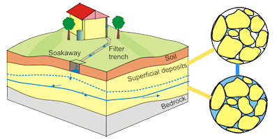
This report provides relevant subsurface information necessary to design effective infiltration-to-the-ground sustainable drainage systems (SuDS) such as shallow soakaways, infiltration trenches and infiltration basins.
The report highlights:
- the presence of any potentially significant constraints that mean an infiltration system should not be installed
- the extent to which the ground will drain
- significant potential for natural ground instability as a result of increased infiltration
- the attenuation capacity of the unsaturated zone
The report contains 1:50 000 scale map extracts showing geology, subsurface properties and natural ground instability hazards where present.
This GeoReport is generated for a point-location, which is used to position the search results so that they are centred on your area of interest. The maps presented cover approximately 2 km2 around the centre point, such that you can visualise changes in subsurface properties across the site. The example report shows how much area is covered in a search.
Notes:
Map extracts are not available in some areas of the UK. See the report availability map below.
All prices include delivery.

